NOAA and Coast Guard survey shallow channels in eastern Chesapeake Bay to update aids to navigation

By Lt j.g. Patrick Debroisse

The area of the Chesapeake Bay along the Eastern Shore of Maryland is one of our nation’s treasures. Home to unique underwater grasses, fish, and shellfish, this complex transition from river to sea is also home to millions of tons of sediment delivered annually from eroding land and streams. Recreational boaters, fisherman, and cruising vessels are keenly aware of the shifting sands and sediment deposits in these shallow waters and rely on aids to navigation (ATON) — a system of beacons and buoys — to travel safely to and from the harbors and docks along the shoreline.

U.S. Coast Guard (USCG) Aids to Navigation Team (ANT) from Crisfield, Maryland, recently requested the assistance of NOAA’s Office of Coast Survey to help identify areas where ATON were in need of repair, relocation, or removal due to the shifting sediment of these nearshore areas. Crew from NOAA research vessel Bay Hydro II and from navigation response team (NRT) 1 (homeported in Stennis, Mississippi) operated an Echoboat autonomous surface vehicle (ASV) from a USCG vessel to survey these shallow waters. 

Lt j.g. Patrick Debroisse readies the Echoboat ASV for hydrographic survey
Lt j.g. Patrick Debroisse (NOAA, junior officer in charge, Bay Hydro II) readies the Echoboat ASV for hydrographic survey in the nearshore waters of the Chesapeake Bay.
Alex Ligon (NOAA NRT1) works with USCG Boatswain Mate (BM) 1 Lee Durfee, BM2 Collin Blugis, and Machinery Technician 3 Matt Kemp to load the ASV on the USCG vessel.
Alex Ligon (NOAA, NRT 1) works with USCG Boatswain Mate (BM) 1 Lee Durfee, BM 2 Collin Blugis, and Machinery Technician 3 Matt Kemp to load the ASV on the USCG vessel.

The team first visited Slaughter Creek, near Taylor’s Island, where the USCG believed sediment in the channel was shifting, requiring potential ATON relocation. The second area was in Pocomoke River, east of Smith Island, where shoaling in the already shallow channel was of concern, as well as the existence of unused ATON anchors. The ASV, equipped with side scan sonar to search for underwater objects, and a multibeam echo sounder to check the contours of the channels, surveyed both areas.

Once the survey data is processed and delivered to the USCG ANT, they can make informed decisions about ATON maintenance. Finding old ATON anchors and recycling them back into service is a potential cost savings for the USCG. NOAA and the USCG plan to operate the Echoboat ASV in this area again, surveying the waters for a possible wreck in Fishing Bay and for old ATON moorings replaced by a day shape.

Echoboat ASV surveys in the Pocomoke River Channel to investigate possible shoaling.
Echoboat ASV surveys in the Pocomoke River channel to investigate possible shoaling.
Alex Ligon (NOAA NRT 1) watches the ASV data in real-time. The ability to watch the data real time allows real-time decision making for survey planning and preliminary products to be provided to the Coast Guard ANT.
Alex Ligon (NOAA, NRT 1) watches the ASV data in real-time, which allows for real-time decision making for survey planning and preliminary products.

Coast Survey recently surveyed the waters of Lake Champlain using the Echoboat ASV.  This portable unit provides flexibility and allows survey teams to further develop procedures and to train more individuals in its use for future operations around the country.

NOAA Office of Coast Survey wraps up a busy 2017 hurricane season

The 2017 Atlantic hurricane season was powerful, with the strongest storms occurring consecutively from late August to early October. The sequential magnitude of four hurricanes in particular—Harvey, Irma, Maria, and Nate—made response efforts challenging for NOAA’s Office of Coast Survey. Coast Survey summarized this season’s response efforts along with the efforts of NOAA Ship Thomas Jefferson (operated by NOAA’s Office of Marine and Aviation Operations) in the following story map.

hurricane-season-storymap

Coast Survey research vessel helps Coast Guard re-establish normal ship traffic in the Chesapeake

Coast Survey’s research vessel, Bay Hydro II, was diverted from its regular hydrographic mission this week to help the U.S. Coast Guard determine if there was a new danger to navigation in the Chesapeake Bay.

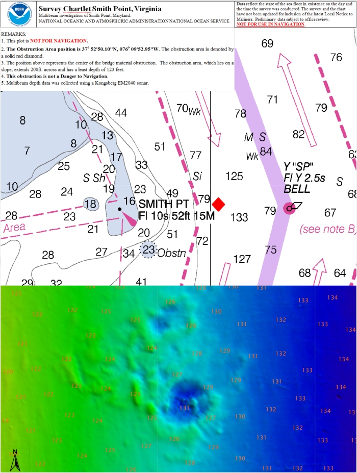
On June 13, 2016, U.S. Coast Guard Sector Hampton Roads was notified that the barge WEEKS 179 lost a large portion of its cargo near the Virginia-Maryland line, in a charted traffic scheme area that takes ships around Smith Point in the Chesapeake Bay. The WEEKS 179, carrying construction materials to New Jersey, lost approximately 25 concrete beams and bridge deck pieces, ranging from 10 ft. to 15 ft. long. While the Coast Guard diverted ship traffic around the area, Bay Hydro II deployed to the site, to establish the cargo’s exact position and determine if it posed a hazard to navigation.

By early the next morning, Bay Hydro II was conducting the search. The survey technicians used side scan sonar to locate the sunken cargo, and then followed it up with their multibeam echo sounder to collect bathymetric data over the field of debris. (While the side scan sonar is typically a better search tool for locating objects in large areas, the multibeam is best for obtaining precise position and depths over the items so the hydrographers can determine if dangers to navigation exist.)

Within hours, the Coast Survey vessel had located the cargo and, even better, had determined that the beams were so deep that they did not pose a danger. The Coast Guard was able to use Bay Hydro II’s information to quickly re-establish normal shipping patterns through the area.

Smith_Point_Chartlet

NOAA R/V Bay Hydro II has a ball meeting the public in Baltimore!

Last week we blogged about Coast Survey’s research vessel Bay Hydro II, a small hydro research vessel that delivers big results. The vessel was heading into Baltimore Harbor for five days of public tours at Star Spangled Spectacular.

The Bay Hydro II crew and headquarters personnel had a great time with everyone — from the kids who learned about charts from an admiral, to the map geeks who enjoyed a discussion down in the hydro weeds. More than 4,000 people toured the Bay Hydro II during the celebration, and we hope they all learned at least a little about hydrographic surveying and nautical charts.

Rear Adm. Gerd Glang explains charts to kids
Rear Admiral Gerd Glang, director of NOAA’s Office of Coast Survey, introduced kids to nautical charts onboard R/V Bay Hydro II.
LTJG Bart Buesseler answers questions from the public
The Officer in Charge of R/V Bay Hydro II, Lt.j.g. Bart Buesseler, must have answered a million questions about surveying, charting, and serving in the NOAA Officer Corps.
Rob Mowery
Rob Mowery, the physical scientist who manages Bay Hydro II‘s surveys, called on his years of NOAA experience to explain hydrography to an inquiring public.
Tours pause for Blue Angels
Okay everyone, take a break! The Blue Angels are coming…

A small hydro research vessel delivers big results

by Dawn Forsythe, Coast Survey communications

Remember when your mom told you, “The best things come in small packages”? It turns out that is true for more than diamonds, puppies, and kids who think they are too short.

Today it was my privilege to ride with the 57-foot Bay Hydro II, one of NOAA’s smallest research vessels, as she came into Baltimore Harbor for the Star Spangled Spectacular, a festival that celebrates the 200th anniversary of our National Anthem. As we sailed alongside the impressive NOAA Ship Okeanos Explorer, past historic Fort McHenry, a 19th century cannon boomed ‒ probably sounding much as it did 200 years ago during the War of 1812, when the British attack was turned back at Baltimore. With that historic reminder, I was struck by how the Bay Hydro II represents Coast Survey’s two-century commitment to the Chesapeake Bay, starting with our surveys in 1843.

The view from NOAA R/V Bay Hydro II, as the NOAA Ship Okeanos Explorer passes historic Fort McHenry
The view from R/V Bay Hydro II, as the NOAA Ship Okeanos Explorer passes historic Fort McHenry

(Historical note: Even though President Jefferson ordered the Survey of the Coast in 1807, the U.S. Coast Survey was not able to assist during the War of 1812. We were still organizing and, in fact, the first superintendent of Coast Survey was in England when war broke out. Ferdinand Hassler was trying to recruit surveying and cartographic experts and was searching for the proper equipment. He was not able to return to the U.S. until after the war. Some historians think Hassler may have been detained in England at what could euphemistically be called a “special invitation” of the British government.)

Bay Hydro II, the successor to the original productive Bay Hydrographer, was only commissioned five years ago. She was built for the Bay. As U.S. Senator Barbara Mikulski wrote in 2009:

“The Port of Baltimore depends on accurate charts to ensure maritime traffic flows freely, and to help keep the Bay safe from environmental disasters that could result from vessels striking uncharted hazards… Investing in advanced technology, like the Bay Hydrographer II and the sonar equipment it uses, is especially important for keeping America competitive in a global arena. Much of the charting equipment and software currently used within NOAA’s hydrographic fleet was first tested and proven right here in the Bay using this vessel’s predecessor.

“I’m proud to have such an advanced test platform in Maryland’s backyard, keeping America safe, and keeping America innovative.”

The Bay Hydro II is meeting Senator Mikulski’s vision for safety and innovation.

BHII in Hampton Roads 2011
Bay Hydro II surveyed in Hampton Roads following Hurricane Irene, speeding the resumption of port operations

Bay Hydro II has an impressive record. She was the first vessel in Norfolk waters after Hurricane Irene and Sandy, searching for underwater debris to speed resumption of shipping and naval operations in Hampton Roads. In addition to leading Coast Survey evaluations of emerging hydrographic survey technologies, she has assisted U.S. Navy researchers who are testing new technologies. She has rescued stranded boaters and removed debris that posed a danger to navigation in the Bay. And by participating in local community events, the Bay Hydro crews have educated tens of thousands of people about the Bay’s marine characteristics and maritime importance.

Speaking of education… At Baltimore’s 2012 Sailabration, nearly 9,000 people toured this mighty little research vessel for an introduction to NOAA’s hydrographic surveys. With more than a million people expected for this year’s Star Spangled Spectacular, from Sep. 11 to Sep. 15, I’d be surprised if the three-person Bay Hydro crew has any voice left on Tuesday.

This weekend, a lot of people are going to discover how a small research vessel delivers big results.

O-I-C Buesseler
Lt.j.g. Bart Buesseler is the officer-in-charge of the R/V Bay Hydro II
Rob Mowery
Rob Mowery, physical scientist technician on the Bay Hydro II, explains survey preparations to a visiting media crew.